
Accelerate Land Cover Segmentation Annotation With Labellerr Using SAM

Table of Contents
- Introduction
- Challenge
- Solution: Labellerr's Role in Land Cover Classification
- Conclusion
- Frequently Asked Questions
Introduction
Land cover segmentation is a crucial task in remote sensing and environmental monitoring, aiming to categorize different land cover types within satellite or aerial imagery.
This problem involves the segmentation of satellite images into multiple classes, such as urban areas, agriculture, forests, water bodies, and more.
Accurate land cover classification provides valuable insights for urban planning, agricultural management, natural resource conservation, and climate change studies.
Annotating large volumes of satellite imagery for land cover classification tasks is essential for training machine learning models to automate this process.
Labellerr, an advanced annotation platform, plays a pivotal role in efficiently annotating satellite imagery to create labeled datasets for training accurate land cover classification models.
Challenge
The complexities of land cover classification by satellite images present a lot of challenges.
High-Resolution Images: Large picture databases are the result of modern remote sensing satellites collecting data on land cover at very high resolutions. Spending a lot of time and money annotating each pixel is not always feasible.
Spectral Complexity: Spectral signatures of multiple land cover classes can be quite similar, particularly along type boundaries (e.g., between shrubland and forests). Differentiating between these classes using tiny spectral differences requires competence on the part of the annotators.
Spatial Heterogeneity: Land cover within a class might vary greatly due to spatial heterogeneity. A forest class, for instance, could include both densely forested and sparsely treed regions, as well as open clearings. This variability must be taken into consideration by the annotators during labeling.
Class Imbalance: Disproportion across classes: for example, there may be a disproportionate amount of water compared to buildings or other forms of land cover. A bias towards the dominant classes and poor performance on less frequent ones can result from this class imbalance.
Temporal Variations: Changes in land cover can occur on a seasonal or even a longer time scale. In order to classify datasets accurately, annotations must take the images' temporal context into account, which may necessitate multi-temporal data.
Overcoming these challenges requires advanced annotation tools and methodologies to streamline the annotation process and generate high-quality labeled datasets essential for training accurate land cover classification models.
Labellerr emerges as a pivotal solution which is equipped with the features to address these challenges and facilitate efficient satellite imagery annotation for land cover classification tasks.
Solution: Labellerr's Role in Land Cover Classification
To address these challenges, companies and researchers employ annotation platforms like Labellerr to streamline the annotation process.
By harnessing Labellerr's capabilities, they can annotate data with increased speed and accuracy, thereby doubling their release velocity for developing AI-powered image analysis software.
Read the full documentation for using SAM in an annotation workflow with Labellerr.
Below we discuss multiple factors by which Labellerr helps teams to overcome challenges.
Intuitive Interface
Labellerr provides an intuitive user interface designed to simplify the annotation process for annotators working on land cover classification tasks.
Its user-friendly design and navigation tools empower annotators to label land cover classes with ease, reducing the learning curve and enhancing productivity.
With Labellerr's intuitive interface, annotators can focus on annotation tasks without being hindered by the complexity of the imagery.
Robust Segmentation Features
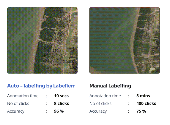
Labellerr incorporates robust segmentation features, including the Segment Anything Model (SAM), which enables precise and accurate delineation of land cover boundaries within satellite imagery.
SAM's advanced algorithms can effectively segment diverse land cover types, regardless of complexity or variability in appearance.
By leveraging SAM's segmentation capabilities, Labellerr ensures the accuracy and reliability of labeled datasets, enhancing the performance of land cover classification models.
To see Labellerr’s segmentation features in action, check out this video:
Cost Savings
Labellerr offers cost savings for land cover classification tasks by optimizing the annotation process and reducing manual labor costs.
Its advanced automation features streamline the annotation workflow, minimizing the need for extensive human intervention.
By automating repetitive tasks and leveraging efficient annotation algorithms, Labellerr enables organizations to annotate large volumes of satellite imagery efficiently and cost-effectively.
Custom Workflows
Labellerr supports customizable workflows tailored to the specific requirements of land cover classification tasks.
Organizations can define custom annotation protocols, designate land cover classes, and customize labeling criteria to suit their unique needs.
This flexibility ensures that annotations are consistent, standardized, and aligned with the objectives of the project, ultimately leading to more reliable and accurate labeled datasets for training land cover classification models.
Active Learning Based Labeling
Labellerr employs active learning techniques to optimize the land cover classification process.
By intelligently selecting the most informative samples for annotation, Labellerr maximizes the efficiency of data labeling, reducing manual effort while improving the performance of trained models.
This active learning-based approach enables organizations to prioritize labeling efforts on data points that are most beneficial for model training, ultimately leading to more accurate and effective land cover classification models.
Automated Import and Export of Data
Labellerr streamlines the process of importing and exporting data for land cover classification tasks with its automated functionalities.
Organizations can seamlessly upload large volumes of satellite imagery into the platform and export annotated data for compatibility with various analysis tools and frameworks.
By automating data import and export processes, Labellerr ensures seamless integration with existing workflows, maximizing workflow efficiency and productivity.
Collaborative Annotation Pipeline
Labellerr facilitates collaboration among annotators with its collaborative annotation pipeline.
Multiple users can work simultaneously on annotating satellite imagery for land cover classification, allowing for distributed workflows and real-time collaboration.
This collaborative approach enhances productivity and ensures consistency and accuracy in the labeled dataset, ultimately improving the performance of land cover classification models.
Automated QA (Quality Assurance):
Labellerr integrates automated quality assurance mechanisms to ensure the accuracy and reliability of annotated land cover classification data.
Advanced algorithms analyze annotations in real-time, flagging inconsistencies or errors for review by annotators.
This automated QA process maintains the quality of the labeled dataset, reducing the risk of errors and ensuring the high performance of trained models in land cover classification tasks.
Conclusion
In conclusion, Labellerr stands as a powerful solution for advancing land cover classification through precise and efficient data annotation.
By addressing the challenges associated with annotating satellite imagery for land cover classification tasks, Labellerr allows organizations to create accurate and reliable datasets essential for training robust classification models.
With its intuitive interface, robust segmentation features, and advanced automation capabilities, Labellerr streamlines the annotation process, enhances collaboration among annotators, and ensures the quality and consistency of labeled data.
Labellerr accelerates progress in the field of remote sensing and environmental monitoring, enabling the development of accurate land cover classification models with applications in urban planning, agriculture, forestry, conservation, and climate change studies.
Schedule a demo call to see how Labellerr can save thousands of dollars for your use case.
Frequently Asked Questions
Q1) What is land cover classification, and why is it important?
Land cover classification is the process of categorizing different types of land cover within satellite or aerial imagery, such as urban areas, agriculture, forests, water bodies, and more.
It is important for various applications, including urban planning, agricultural management, natural resource conservation, and climate change studies.
Q2) How does Labellerr assist in annotating satellite imagery for land cover classification?
Labellerr provides advanced annotation tools and features specifically designed for annotating satellite imagery for land cover classification tasks.
Its intuitive interface, robust segmentation capabilities, and automation features streamline the annotation process, enabling annotators to label land cover classes accurately and efficiently.

Simplify Your Data Annotation Workflow With Proven Strategies
.png)